Skip to content
️ Love Canadian Parks? Get Your Sticker Collection Now! Shop All 150 Parks Stickers →

Shop Our Complete Collection

All 48 Canadian national parks, 150+ unique designs, premium vinyl stickers. Perfect for water bottles, laptops, RVs, and camp gear.

Shop All Parks Stickers Call for Bulk Orders

4 Sizes Available: 3" ($5.99) • 4" ($6.99) • 5" ($8.99) • 6" ($14.99)
Free Shipping on orders $75+ across Canada

The Ultimate Guide to Canada's 48 National Parks & Reserves

Explore the most comprehensive, data-rich guide to every Canadian national park and reserve. Featuring detailed statistics, expert planning tools, hidden gems, and insider knowledge from Arctic tundra to coastal rainforests.

48 Protected Areas
328,198 km² Protected
25M+ Annual Visitors
1885 First Park Est.

Park Categories at a Glance

Compare Canada's parks by size, accessibility, difficulty, and visitor experience to find your perfect adventure.

️ Largest Parks (by area)

Wood Buffalo44,807 km²
Quttinirpaaq37,775 km²
Thaidene Nëné26,376 km²
Jasper11,000 km²

Most Visited Parks

Banff~4.1M visitors
Jasper~2.5M visitors
PEI~1.6M visitors
Pacific Rim~1.1M visitors

Most Remote Parks

Quttinirpaaq~50-100 visitors/yr
Qausuittuq~10-20 visitors/yr
Aulavik~10-30 visitors/yr
Tuktut Nogait~20-50 visitors/yr

National Parks of Canada

37 spectacular national parks protecting Canada's most iconic landscapes, from the highest peaks to the deepest fjords

Banff National Park

Alberta UNESCO World Heritage
6,641 km² Total Area
3,618m Highest Peak (Mt. Forbes)
4.1M Annual Visitors
1885 Established
53 Mammal Species
Turquoise waters of Moraine Lake with mountain peaks in Banff National Park

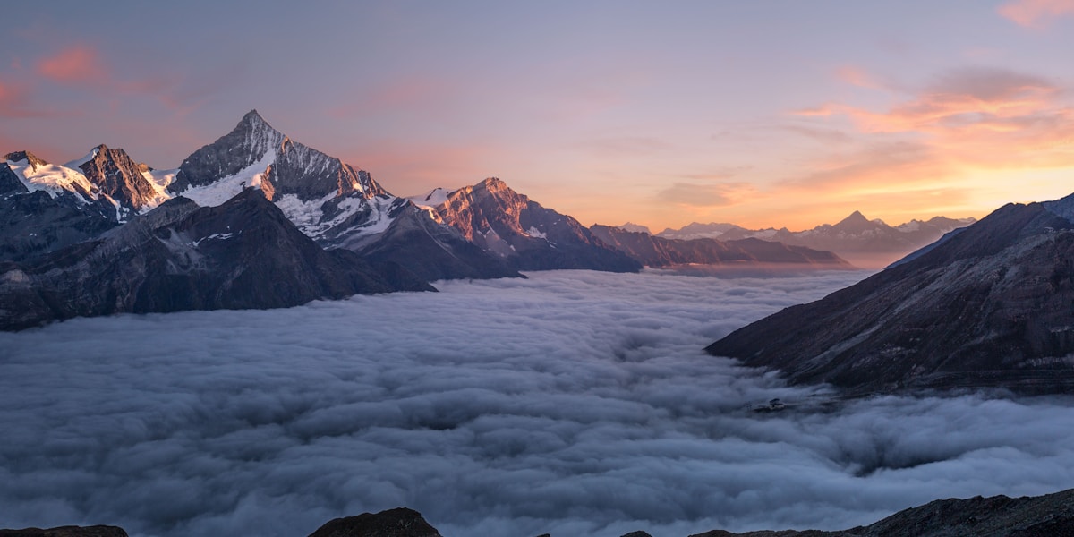
Image Source for YOUR version: Search Unsplash Pro, Getty Images, or Shutterstock for: "Moraine Lake Banff sunrise" or "Lake Louise turquoise water aerial". Budget: $10-30 per image. Free alternative: Parks Canada Media Gallery (requires attribution).

Banff National Park, established in 1885, holds the prestigious distinction of being Canada's first national park and the world's third, making it a cornerstone of global conservation history. Nestled in the heart of the Canadian Rockies in Alberta, Banff encompasses 6,641 square kilometers of pristine mountain wilderness, featuring the iconic turquoise lakes, soaring peaks, vast icefields, and abundant wildlife that have made it one of the most photographed and visited national parks on Earth.

The park attracts over 4.1 million visitors annually, drawn by legendary destinations like Lake Louise, Moraine Lake, and the Icefields Parkway. Despite this popularity, Banff contains vast wilderness areas where solitude and wildlife encounters remain abundant. The town of Banff, located within park boundaries, serves as the primary hub, offering world-class amenities while Parks Canada carefully manages development to preserve the park's ecological integrity.

The Birth of Canada's National Parks System

Banff's creation story is legendary in conservation circles. In 1883, three Canadian Pacific Railway workers—Franklin McCabe, William McCardell, and Thomas McCardell—discovered hot springs on Sulphur Mountain while working on the transcontinental railway. Recognizing their commercial potential, the Canadian government reserved the area around the Cave and Basin Hot Springs in 1885, initially as a small 26-square-kilometer reserve. This modest beginning sparked Canada's national park system and influenced park creation worldwide.

The Cave and Basin site remains accessible today, featuring restored historic pools, interpretive exhibits, and the original thermal springs that Indigenous peoples had used for over 10,000 years before European contact. The Stoney Nakoda First Nations, who called this area home, knew these springs as sacred healing waters long before they caught the attention of railway workers.

Hidden Gems & Lesser-Known Facts

  • Wildlife Crossings Pioneer: Banff pioneered wildlife crossing infrastructure with over 44 overpasses and underpasses specifically designed for animal movement. These structures have enabled more than 200,000 wildlife crossings since monitoring began, reducing vehicle collisions by over 80%. The crossings serve as models studied by highway planners worldwide, demonstrating that human infrastructure and wildlife conservation can coexist.
  • The Turquoise Mystery Solved: The stunning turquoise color of Lake Louise, Moraine Lake, and Peyto Lake comes from "glacial flour"—rock particles ground so finely by glacial erosion that they remain suspended in the water. These particles refract sunlight, creating the spectacular blue-green hues. The color intensity varies dramatically with seasonal glacial melt, appearing most vivid in July and August when glacial melt peaks.
  • Secret Lakes Without Crowds: While tourists queue for hours at Moraine Lake (which now requires advance reservations), locals know about hidden alternatives offering similar beauty with 10% of the crowds: Consolation Lakes (easy 3km hike from Moraine Lake), Boom Lake (moderate 10km round-trip), and Rockbound Lake (challenging 16km). These lakes provide the same glacial turquoise waters and mountain amphitheaters without the chaos.
  • Underground Ice Age: The Castleguard Caves system extends over 20 kilometers underground beneath the Columbia Icefield, making it one of the longest cave systems in Canada. The caves contain ice formations dating back thousands of years and provide scientists with climate data preserved in ancient ice. Access is strictly controlled and limited to scientific research due to the caves' fragility and scientific importance.
  • Banff's Elk Urban Problem: The town of Banff faces an unusual challenge—elk have become so comfortable with humans that they wander through town blocking traffic, bedding down on golf courses, and refusing to yield to vehicles. The park has installed special gates, fencing, and aversive conditioning programs to manage human-habituated elk. During the fall rut, bull elk become aggressive, leading to numerous close calls with tourists who don't respect safe distances.
  • The Ghost Hotel: The Fairmont Banff Springs Hotel, opened in 1888, is allegedly haunted by multiple ghosts including a bride who fell down the stairs on her wedding day (now known as the "ghost bride"), and a former bellman named Sam who helps guests find their rooms. The hotel embraces its haunted reputation, offering ghost tours during the Halloween season.
  • Moraine Lake's Movie Fame: Moraine Lake appeared on the Canadian $20 bill from 1969-1979, making it one of the most recognized Canadian landscapes globally. The lake sits in the Valley of the Ten Peaks, though ironically, you can actually see more than ten peaks from certain vantage points. The road to Moraine Lake now closes when the parking lot fills (often by 5:30 AM in summer), making sunrise visits essential.
  • Wildlife Highway 93: The Bow Valley Parkway (Highway 1A) serves as an alternative to the Trans-Canada Highway and offers significantly better wildlife viewing. Parks Canada often closes portions of the road in spring to protect bears feeding on roadside vegetation, demonstrating the park's commitment to wildlife over human convenience.

Wildlife Encounters & Viewing Opportunities

Banff hosts 53 mammal species, including grizzly bears, black bears, wolves, cougars, elk, bighorn sheep, mountain goats, and wolverines. The park's wildlife corridors are carefully managed to allow animal movement between protected areas while minimizing human conflicts.

Elk
95% chance (year-round)
Black Bear
70% chance (May-Oct)
Grizzly Bear
40% chance (Jun-Sep)
Wolf
15% chance (dawn/dusk)
Golden Eagle
60% chance (mountain areas)
Mountain Goat
80% chance (alpine areas)

Planning Your Visit: Month-by-Month Guide

Month Weather Crowds Best For Considerations
January-March -15°C to -5°C, Heavy snow Low Skiing, ice climbing, winter photography Many roads closed, extreme cold gear essential
April-May 0°C to 15°C, Variable Low-Moderate Wildlife viewing (bears emerging), fewer crowds Moraine Lake Road closed until late May, muddy trails
June 10°C to 20°C, Rain possible Moderate Wildflowers, waterfalls at peak flow Moraine Lake opens late May/early June, book accommodations ahead
July-August 15°C to 25°C, Occasional thunderstorms EXTREME Hiking, all facilities open, warm weather Moraine Lake parking full by 5:30 AM, advance shuttle reservations REQUIRED
September 5°C to 15°C, Cool nights Moderate-High Larch trees golden, elk rut, fewer crowds Best month for balance of weather and crowds
October 0°C to 10°C, First snow Low Fall colors, photography, solitude Many trails muddy or snowy, facilities closing
November-December -10°C to 0°C, Snow Very Low Early skiing, holiday lights, quiet parks Moraine Lake Road closed, Lake Louise Ski Resort opens

Insider Tips from Park Veterans

Beat the Moraine Lake Crowds: The Moraine Lake situation has reached critical mass. The parking lot fills by 5:30-6:00 AM in summer, and once full, the road closes for the day. Your options: (1) Book the Parks Canada shuttle months in advance through the reservation system, (2) Arrive before 5:30 AM (seriously), (3) Stay at Moraine Lake Lodge (book a year ahead), or (4) Skip it entirely and visit the equally beautiful but crowd-free Consolation Lakes or Boom Lake instead.

Lake Louise Strategy: Similarly packed. Park at the overflow lot at the ski resort and take the free shuttle, or hike the Lake Agnes Tea House trail which starts from the same parking area but sees fewer people. The tea house itself (built 1901) serves fresh-baked goods and tea at 2,135 meters elevation—a worthy destination in itself.

Best Wildlife Viewing: Drive the Bow Valley Parkway (Highway 1A) at dawn or dusk. This scenic alternative to the Trans-Canada Highway offers better wildlife sightings and less traffic. Vermilion Lakes Drive, just outside Banff town, provides excellent sunrise/sunset photography and frequent bear, elk, and beaver sightings.

Free Parking Hack: Park at the Banff train station (free) and take the Roam public transit throughout the park. The local bus system connects all major attractions and costs just $2 per ride, saving parking headaches and fees.

Accommodation Booking: For summer visits, book accommodations 6-12 months in advance. For same-day booking, check the Parks Canada website for cancellations at park campgrounds, which are released at noon daily.

Essential Costs & Budgeting

Item Cost (CAD) Notes
Parks Canada Discovery Pass (Annual) $72.25/adult Pays for itself after 7 days. Covers all national parks
Day Pass $10.50/adult Valid until 4 PM next day
Camping (Serviced) $38-$49/night Sites at Tunnel Mountain, Lake Louise, Two Jack
Camping (Unserviced) $22-$28/night More rustic but still vehicle accessible
Backcountry Permit $10/person/night Plus $12 reservation fee. Book 90 days ahead
Moraine Lake Shuttle (if available) $8 round-trip Advance reservation required, sells out fast
Lake Agnes Tea House $10-15 Cash only! Bring Canadian currency

Budget Estimate: A 3-day visit for two people: Discovery Pass ($145), camping 2 nights ($100), food ($150), gas ($50) = approximately $445 CAD total, excluding travel to Alberta.

Official Source: Parks Canada - Banff National Park | Additional data: National Geographic Travel

Jasper National Park

Alberta UNESCO World Heritage
11,000 km² Total Area
3,747m Highest Peak (Mt. Columbia)
2.5M Annual Visitors
1907 Established
Dark Sky Preserve Status
Maligne Lake and Spirit Island in Jasper National Park

Image Source: Search for "Maligne Lake Spirit Island aerial" or "Athabasca Glacier Jasper" on Shutterstock/Getty. Alternative: "Columbia Icefield skywalk". Budget: $15-40/image.

Jasper National Park is the largest national park in the Canadian Rockies, encompassing 11,000 square kilometers of pristine wilderness in Alberta. Established in 1907 and designated a UNESCO World Heritage Site as part of the Canadian Rocky Mountain Parks, Jasper offers a wilder, less crowded alternative to its famous neighbor Banff, while delivering equally spectacular mountain scenery, abundant wildlife, and world-class outdoor recreation.

The park attracts approximately 2.5 million visitors annually—significantly fewer than Banff despite being nearly twice the size. This lower density creates better opportunities for solitude, wildlife encounters, and experiencing genuine wilderness. Jasper is also the world's second-largest Dark Sky Preserve, making it one of the premier stargazing destinations on Earth.

Dark Sky Preserve & Astronomy

In 2011, Jasper achieved designation as a Dark Sky Preserve—at 11,000 km², it's the second-largest accessible dark sky preserve globally. The park's remote location, strict light pollution controls, and high elevation create near-perfect conditions for astronomy. On clear nights, the Milky Way casts visible shadows, and visitors can see an estimated 10,000+ stars with the naked eye compared to just 250-500 in urban areas.

The annual Jasper Dark Sky Festival, held every October, attracts astronomers and astrophotographers from around the world. The event features telescope viewings, astrophotography workshops, planetarium shows, and talks from leading astronomers. Even without the festival, Jasper's dark skies make every clear night a spectacular show—the aurora borealis frequently dances overhead from September through April.

Hidden Gems & Lesser-Known Facts

  • Spirit Island Secret: Spirit Island on Maligne Lake is one of Canada's most photographed landscapes and appeared in countless films and advertisements. However, it's only accessible by boat tour or private kayak—there's no road access. Most tourists never realize the "island" isn't actually an island but a peninsula that appears island-like from certain angles. The boat tour operates May-October and books solid months in advance.
  • Athabasca Glacier Retreat: The Athabasca Glacier, North America's most-visited glacier, is retreating at an alarming rate. Since 1844, it has lost over 50% of its volume and retreated more than 1.5 kilometers. Markers along the trail to the glacier face show where the ice stood in previous decades—a sobering visual representation of climate change. The glacier continues to recede 5 meters per year.
  • Wildlife Superiority: Jasper's lower visitor density and larger wilderness areas result in significantly better wildlife viewing than Banff. The park supports healthy populations of grizzly bears, black bears, wolves, caribou, elk, moose, bighorn sheep, and mountain goats. Wildlife jams along the Icefields Parkway are common—bears, elk, and bighorn sheep frequently cause traffic backups as tourists stop to photograph them.
  • Miette Hot Springs: At 54°C (129°F), Miette Hot Springs features the hottest mineral water in the Canadian Rockies. The springs were developed by the Canadian Pacific Railway in 1913 and remain a popular destination. The modern pools (cooled to a comfortable 39-40°C) offer stunning mountain views. Unlike Banff's Cave and Basin (closed for swimming), Miette allows soaking year-round.
  • The Icefields Parkway: The 232-kilometer Icefields Parkway connecting Jasper and Banff is consistently rated one of the world's most scenic drives. The road passes beneath 25 glaciers, crosses wildflower meadows, and winds through pristine valleys. Wildlife sightings are virtually guaranteed. Travel tip: Drive north-to-south (Jasper to Banff) for better views from the right-hand lane and easier pulloff access.
  • Mount Edith Cavell: Named after a British WWI nurse executed for helping Allied soldiers escape Belgium, Mount Edith Cavell (3,363m) features one of Jasper's most dramatic landscapes. The Angel Glacier clings to its north face, and the trail to Cavell Meadows offers accessible alpine hiking with stunning views. The steep, narrow access road opens late June and closes at first snow.
  • The Whistlers: The Jasper SkyTram whisks visitors 2,263 meters up Whistlers Mountain in just 7 minutes—the highest and longest aerial tramway in Canada. From the upper terminal, a 1.4km trail climbs to the summit at 2,464m, offering 360-degree views of six mountain ranges and the Columbia Icefield. Arrive before 9 AM or after 5 PM to avoid crowds.
  • Valley of Five Lakes: This easy 4.6km loop trail visits five stunning turquoise lakes, each a different shade of blue-green depending on depth and mineral content. Despite being one of Jasper's most beautiful short hikes, it sees far fewer visitors than comparable trails in Banff. Early morning visits often mean having entire lakes to yourself.

Wildlife Viewing Guide

Elk
90% chance (year-round)
Grizzly Bear
60% chance (May-Oct)
Wolf
25% chance (dawn/dusk)
Bighorn Sheep
85% chance (roadside)
Caribou
15% chance (alpine areas)
Beaver
70% chance (lakes at dusk)

Best Time to Visit: Seasonal Guide

Season Weather Highlights Considerations
Winter (Dec-Mar) -20°C to -5°C Skiing, ice climbing, frozen waterfalls, quiet trails, ice bubbles in Abraham Lake Extreme cold, many roads closed including Maligne Lake Road, dress in layers
Spring (Apr-May) -5°C to 15°C Bears emerging, fewer crowds, shoulder season rates, waterfalls at peak Unpredictable weather, muddy trails, Maligne Lake Road opens late May
Summer (Jun-Aug) 10°C to 25°C All roads open, wildflowers peak in July, long daylight hours, warm weather Most crowded period, book accommodations 6+ months ahead, mosquitoes in July
Fall (Sep-Oct) 0°C to 15°C Fall colors, elk rut, Dark Sky Festival, fewer crowds, crisp clear days Snow possible after mid-September, Maligne Lake Road closes mid-October

Insider's Choice: September-early October offers the best balance of weather, wildlife activity (elk rut), fall colors, manageable crowds, and clear dark skies for stargazing. The Dark Sky Festival typically runs mid-October.

Essential Costs

Item Cost (CAD) Notes
Parks Canada Discovery Pass $72.25/adult Covers all Canadian national parks
Jasper SkyTram $60-70/adult Book online for discounts
Maligne Lake Boat Tour $75-95/adult 2-hour tour to Spirit Island, book months ahead
Columbia Icefield Skywalk $35-45/adult Glass-floor platform, can skip if budget-conscious
Camping (Serviced) $32-$43/night Whistlers, Wapiti, Wabasso campgrounds
Miette Hot Springs $8-10/adult Towel rental $2 extra

Sources: Parks Canada - Jasper | International Dark-Sky Association

Pacific Rim National Park Reserve

British Columbia
511 km²Total Area
1.1MAnnual Visitors
75kmCoastline
Wild Pacific coastline at Pacific Rim

Search: "Long Beach Tofino storm watching" "West Coast Trail Pacific Rim" on Getty/Shutterstock

Pacific Rim encompasses three distinct units: Long Beach (endless sandy beach perfect for storm watching), the Broken Group Islands (kayaking paradise with 100+ islands), and the legendary West Coast Trail (75km of challenging coastal hiking). Storm watching season (Nov-Feb) brings massive Pacific storms with 30m waves crashing against ancient rainforest.

Hidden Gems

  • Storm Watching Capital: Tofino becomes Canada's storm watching mecca November-February with massive Pacific storms
  • West Coast Trail History: Built as "life-saving trail" for shipwreck survivors—this coast claimed hundreds of ships
  • Tsunami Debris: Still finding debris from 2011 Japan tsunami washing ashore

Best Time: March-April for gray whale migration (20,000 whales!), July-August for warm weather, Nov-Feb for storm watching

Gros Morne National Park

Newfoundland and Labrador UNESCO World Heritage
1,805 km²Total Area
806mHighest Peak
500M yrsGeology Age
Tablelands and Western Brook Pond

Search: "Tablelands Gros Morne Earth's mantle" "Western Brook Pond fjord aerial"

Gros Morne is a geological wonderland and UNESCO World Heritage Site. The Tablelands expose Earth's mantle—orange rock from deep underground pushed to surface 500 million years ago. Western Brook Pond is a landlocked fjord with 600m cliffs accessible only by boat tour after 3km hike.

Hidden Gems

  • Walk on Earth's Mantle: The Tablelands are one of few places on Earth where you can walk on the planet's mantle
  • Plate Tectonics Proof: Park's geology provided key evidence for continental drift theory
  • Moose Capital: Highest moose density in North America—150,000+ on the island

Best Time: June-September. July-August for boat tours and warmest weather.

Wood Buffalo National Park

Alberta & Northwest Territories UNESCO World Heritage Largest Park in Canada
44,741 km² Total Area
1922 Established
~3,000 Annual Visitors
6,000+ Wild Bison
Boreal Ecosystem Type
Wood Buffalo National Park bison herd

Image Source for YOUR version: Search Getty Images Premium or Alamy for: "Wood Buffalo National Park bison herd Alberta" or "whooping crane nesting Wood Buffalo". Parks Canada Media Gallery also has official images.

Wood Buffalo National Park stands as Canada's largest national park and one of the world's largest protected areas, spanning an incredible 44,741 square kilometers across Alberta and the Northwest Territories. Established in 1922 to protect the last remaining herds of wood bison, this UNESCO World Heritage Site now protects the world's largest free-roaming wood bison population and serves as the only natural nesting site for the endangered whooping crane.

Hidden Gems & Lesser-Known Facts

  • The Salt Plains: One of North America's largest inland salt flats, covering 750 square kilometers with surreal white landscapes and salt-loving plant species found nowhere else in Canada
  • Peace-Athabasca Delta: The world's largest boreal inland delta, three times the size of the Mississippi Delta, with 38 million waterfowl using it during migration
  • Karst Topography: Contains the world's finest examples of gypsum karst landforms with sinkholes reaching 100 meters deep and underground cave systems
  • Dark Sky Preserve: Zero light pollution allows viewing of aurora borealis 200+ nights per year and the clearest Milky Way views in North America
  • Ancient Flyway: Critical stopover on the Central Flyway with 227 bird species including the entire world population of nesting whooping cranes (73 birds as of 2024)
  • Bison DNA Bank: Home to genetically pure wood bison, the largest land mammal in North America weighing up to 1,000 kg, with conservation breeding programs supplying herds worldwide
  • Remote Accessibility: No roads enter the park; access only via winter ice roads (January-March), float planes, or multi-day canoe expeditions

Wildlife Probability Guide

Wood Bison
98% chance (6,000+ population)
Whooping Crane
15% chance (April-Oct, nesting grounds)
Gray Wolf
45% chance (follows bison herds)
Bald Eagle
70% chance (delta region)
Black Bear
60% chance (boreal forest)
Moose
55% chance (wetland areas)

Month-by-Month Planning Guide

Month Weather Crowds Best For Considerations
Jan-Mar -25°C to -35°C Very Low Winter ice road access, aurora viewing Only road access period, extreme cold preparation required
Apr-May -5°C to 15°C Very Low Spring migration, whooping crane arrival Breakup season, no road access, flight access only
Jun-Aug 15°C to 25°C Low-Moderate Canoe expeditions, bison viewing, endless daylight Peak season, book flights 3+ months ahead, mosquitoes intense
Sep-Oct 5°C to 15°C Low Fall colors, reduced bugs, aurora season begins Early snowfall possible, fewer flight options
Nov-Dec -20°C to -30°C Very Low Aurora borealis peak, winter photography No road access until January, limited services

Cost Breakdown (Per Person, 4-Day Trip)

Expense Budget Mid-Range Luxury
Float Plane Charter (Fort Smith round-trip) $800-1,200 $1,200-1,800 $2,000-3,500
Accommodation (Fort Smith base) $100-150/night $180-250/night $300-500/night
Guided Tour Package $500-800 $1,200-2,000 $3,500-5,000
Food & Supplies $200-300 $350-500 $600-900
Permits & Park Fees $50-100 $50-100 $50-100
Total Estimate $1,650-2,550 $2,980-4,650 $6,450-10,000

Best Time: June-August for accessibility and 20-hour daylight. January-March for winter ice road adventures and aurora borealis. Book all services 6+ months in advance.

Yoho National Park

British Columbia UNESCO World Heritage
1,313 km² Total Area
1886 Established
~800,000 Annual Visitors
3,199m Highest Peak (Mt. Goodsir)
Burgess Shale Fossil Site
Yoho National Park Emerald Lake

Image Source for YOUR version: Search Unsplash Pro or Adobe Stock for: "Emerald Lake Yoho British Columbia" or "Takakkaw Falls Yoho winter". Natural Bridge and spiral tunnels also make excellent visuals.

Yoho National Park, whose Cree name means "awe and wonder," delivers on its promise with some of the Canadian Rockies' most spectacular waterfalls, pristine alpine lakes, and the world-renowned Burgess Shale fossil beds containing 508-million-year-old marine creatures. This 1,313 square kilometer park in British Columbia features 28 peaks over 3,000 meters and protects one of the most significant paleontological discoveries in history.

Hidden Gems & Lesser-Known Facts

  • Burgess Shale: UNESCO World Heritage fossil site preserving 120,000+ specimens of Cambrian marine life with soft tissue detail, accessible only via guided hikes (limited to 15 people/day, book 4+ months ahead)
  • Takakkaw Falls: Canada's second-highest waterfall at 373 meters (7x higher than Niagara), with thunderous roar audible 1km away and mist creating constant rainbows
  • Natural Bridge: Kicking Horse River carved through solid rock creating a natural stone arch, continuing to erode at 1-2cm per year
  • Spiral Tunnels: Engineering marvel from 1909 where trains spiral through Cathedral Mountain and Ogden Mountain in figure-eight loops to reduce gradient
  • Emerald Lake: Glacial silt creates vivid emerald color that changes intensity with sunlight; home to the historic Emerald Lake Lodge (1902)
  • Iceline Trail: One of Canada's top 10 day hikes traversing active glacial zones with 20+ glacier viewpoints and alpine meadow explosions in July-August
  • Lake O'Hara: Alpine paradise accessible via lottery bus system (only 42 spots/day), featuring 80km of trails around crystalline lakes—most exclusive hiking destination in Canada

Wildlife Probability Guide

Mountain Goat
85% chance (alpine areas)
Elk
70% chance (valley floors)
Grizzly Bear
40% chance (requires vigilance)
Golden Eagle
50% chance (high elevation)
Hoary Marmot
95% chance (talus slopes, very vocal)
Caribou
25% chance (endangered, remote areas)

Month-by-Month Planning Guide

Month Weather Crowds Best For Considerations
Jan-Apr -15°C to 5°C Very Low Ice climbing, backcountry skiing, frozen waterfalls Takakkaw Falls Road closed, Lake O'Hara inaccessible
May-Jun 5°C to 18°C Low-Moderate Waterfall peak flow, wildflower start, fewer crowds Takakkaw Road opens late June, snow on high trails
Jul-Aug 10°C to 25°C Very High Alpine meadow blooms, all trails open, Burgess Shale hikes Book Lake O'Hara lottery 3 months ahead, very busy weekends
Sep-Oct 0°C to 15°C Moderate Larch trees golden, wildlife active, crisp weather Lake O'Hara season ends mid-Oct, early snowfall possible
Nov-Dec -10°C to -20°C Very Low Solitude, winter photography, Northern Lights Limited facilities, avalanche terrain knowledge required

Cost Breakdown (Per Person, 3-Day Trip)

Expense Budget Mid-Range Luxury
Accommodation (Field, BC) $120-180/night $220-350/night $450-800/night (Emerald Lake Lodge)
Lake O'Hara Bus (if lottery won) $20 $20 $20 (extremely limited)
Burgess Shale Guided Hike $110-150 $110-150 $110-150 (same price, limited spots)
Food & Dining $150-250 $300-450 $600-900
Park Entry & Activities $50-100 $50-150 $50-200
Total Estimate $450-680 $700-1,120 $1,230-2,070

Best Time: Mid-July to mid-September for all trails open and alpine flowers. Late September for larch colors without crowds. Lake O'Hara lottery opens in April for summer reservations.

Kootenay National Park

British Columbia UNESCO World Heritage
1,406 km²Total Area
1920Established
~550,000Annual Visitors
Hot SpringsRadium Pools
Paint PotsOchre Beds
Kootenay National Park Paint Pots

Image Source: Search Adobe Stock or Getty for: "Kootenay Paint Pots ochre" or "Radium Hot Springs pools British Columbia"

Kootenay National Park protects 1,406 km² of diverse ecosystems ranging from glacial valleys to arid grasslands, connected by the spectacular 94-kilometer Banff-Windermere Highway. Home to natural hot springs, vibrant ochre beds, and dramatic canyons, this park showcases the incredible geological and ecological diversity of the Canadian Rockies.

Hidden Gems

  • Paint Pots: Sacred Indigenous ochre beds with vivid orange-red clay pools, used for ceremonial paint for thousands of years, commercially mined 1914-1920
  • Marble Canyon: 600-meter gorge only 3 meters wide carved by Tokumm Creek, with thundering waterfalls and swirling turquoise water
  • Radium Hot Springs: Odorless mineral pools (39°C year-round) fed by ancient aquifers, open 365 days with winter steam creating magical atmosphere
  • Floe Lake: Stunning alpine lake backed by massive Rockwall cliff face rising 1,000 meters, accessed via challenging 10.5km hike
  • Stanley Glacier Trail: Post-fire landscape from 2003 Tokumm Creek fire showing forest regeneration, ending at hanging glacier viewpoint

Best Time: June-September for hiking and hot springs. May-June for wildflowers. Year-round for Radium Hot Springs soaking.

Waterton Lakes National Park

Alberta UNESCO World Heritage Biosphere Reserve
505 km²Total Area
1895Established
~500,000Annual Visitors
1,000+Plant Species
150mLake Depth
Waterton Lakes Prince of Wales Hotel

Image Source: Search Shutterstock or Alamy for: "Waterton Lakes Prince of Wales Hotel" or "Crypt Lake hike Waterton Alberta"

Waterton Lakes National Park is where the mountains meet the prairies in dramatic fashion, forming the Canadian half of Waterton-Glacier International Peace Park. With the world's highest diversity of wildflowers and extreme weather systems colliding, this compact 505 km² park delivers outsized natural beauty and ecological significance.

Hidden Gems

  • Crypt Lake Trail: Voted Canada's #1 hike, featuring boat access, mountain tunnel crawl, cliff-hugging ladder, and waterfall passage to alpine cirque
  • Red Rock Canyon: Argillite rock rich in iron oxidizes to brilliant red-purple, creating Martian landscape with crimson creek bottom
  • Wind Corridor: Chinook winds reach 120 km/h in winter, creating Canada's warmest winter temperatures (up to 20°C in January)
  • Bison Paddock: Plains bison herd viewable from loop road, part of species restoration program
  • Wildflower Capital: Over 1,000 plant species (more than entire provinces) due to prairie-mountain-parkland convergence
  • International Peace Park: World's first (1932), shares ecosystem with Montana's Glacier National Park

Best Time: July-August for wildflower peak and Crypt Lake boat access. September for larch colors and reduced crowds. Winds strongest December-March.

Cape Breton Highlands National Park

Nova Scotia Coastal Highlands
949 km²Total Area
1936Established
~600,000Annual Visitors
18 SpeciesWhales/Dolphins
Cabot TrailScenic Drive
Cape Breton Highlands Cabot Trail

Image Source: Search Getty Premium or Unsplash for: "Cabot Trail Cape Breton autumn" or "Skyline Trail boardwalk Nova Scotia sunset"

Cape Breton Highlands National Park crowns the northern tip of Nova Scotia with 949 km² of dramatic coastal cliffs, forested river canyons, and windswept plateaus. The legendary Cabot Trail winds through the park offering some of North America's most spectacular ocean-highland vistas where moose, whales, and eagles thrive.

Hidden Gems

  • Skyline Trail: 8.2km coastal plateau hike ending at dramatic cliff-edge boardwalk 335m above Gulf of St. Lawrence, sunset pilgrimage spot
  • Fishing Cove Trail: Backcountry paradise requiring 16km round-trip descent to pristine beach with waterfall, wilderness camping available
  • Acadian Forest: Ancient temperate rainforest with 350-year-old sugar maples and yellow birch, moss-draped and cathedral-like
  • Whale Migration Route: 18 species including pilot whales, minke, humpback, and rare North Atlantic right whales (June-October)
  • Bog Ecosystem: Rare coastal raised bogs with carnivorous pitcher plants and round-leaved sundews
  • Celtic Heritage: Scottish Gaelic still spoken in surrounding communities, traditional music sessions in nearby villages

Best Time: September-October for fall colors and fewer crowds. June-July for whale watching. July-August warmest but busiest. Winter (Nov-Apr) for solitude but many facilities closed.

Elk Island National Park

Alberta Dark Sky Preserve
194 km²Total Area
1913Established
~400,000Annual Visitors
700+Bison Population
Class 1Dark Sky Rating
Elk Island bison dark sky

Image Source: Search Adobe Stock for: "Elk Island bison herd Alberta" or "Astotin Lake aurora borealis". Dark sky astrophotography opportunities excellent.

Elk Island National Park is a fully enclosed wildlife sanctuary 35km east of Edmonton protecting both plains and wood bison in one of Canada's most successful conservation stories. As a Class 1 Dark Sky Preserve, it offers world-class stargazing alongside guaranteed bison encounters in an accessible parkland-boreal ecosystem.

Hidden Gems

  • Bison Conservation Bank: Genetic source population for restoration projects worldwide—over 1,500 bison shipped to establish new herds across North America
  • Dark Sky Preserve: Closest Class 1 dark sky site to major city (Edmonton), Milky Way visible 90% of clear nights, aurora frequent
  • Two Bison Species: Only park protecting both plains bison (south side) and wood bison (north side), separated by fence and highway
  • Highest Mammal Density: 44 species/km² including elk, moose, deer, beaver, coyote—virtually guaranteed wildlife viewing
  • Beaver Boardwalk: 3km floating trail through active beaver wetlands with lodges, dams, and interpretive stations
  • Winter Access: Groomed trails for snowshoeing, cross-country skiing, and fat biking with cozy warming huts

Best Time: Year-round park. June-August for camping and paddling. January-February for bison in snow and aurora. September-October for elk rutting behavior. New moon weekends for astronomy programs.

Nahanni National Park Reserve

Northwest Territories UNESCO World Heritage Wilderness
30,000 km²Total Area
1976Established
~1,000Annual Visitors
92mVirginia Falls Height
300kmSouth Nahanni River
Nahanni National Park Virginia Falls

Image Source: Search National Geographic or Parks Canada Media for: "Virginia Falls Nahanni" or "South Nahanni River canyons Northwest Territories"

Nahanni National Park Reserve protects 30,000 km² of pristine northern wilderness centered on the legendary South Nahanni River. Home to Virginia Falls (twice the height of Niagara), four massive canyons, hot springs, and karst formations, this remote park offers one of the world's premier wilderness paddling experiences through untouched subarctic landscapes.

Hidden Gems

  • Virginia Falls (Nailicho): 92-meter waterfall splits around Mason's Rock creating twin cascades, accessible only by multi-day float plane + canoe expedition
  • The Four Canyons: Limestone gorges up to 1,200m deep carved by South Nahanni River, with vertical walls and Class III-IV whitewater
  • Rabbitkettle Hotsprings: Canada's largest tufa mounds (27m high) built by mineral-depositing thermal springs, sacred site requiring special permit
  • Headless Range: Legendary mountain range named for mysterious deaths of prospectors in early 1900s, fueling myths still told today
  • Karst Landscape: Extensive cave systems including Grotte Valerie (5th longest in Canada) with ice formations and underground rivers
  • No Roads: Accessible only by float plane from Fort Simpson ($2,000+ per person), preserving absolute wilderness character

Best Time: July-August only navigable season. Most visitors book 12-14 day guided canoe expeditions. Fly-in costs $3,000-8,000 per person. Permits required 6+ months ahead.

Gwaii Haanas National Park Reserve

British Columbia (Haida Gwaii) UNESCO World Heritage Haida Heritage
1,495 km²Land Area
3,400 km²Marine Area
1988Established
~2,500Annual Visitors
500+Haida Sites
Gwaii Haanas totem poles

Image Source: Search Getty or Alamy for: "SGang Gwaay totem poles Haida Gwaii" or "Gwaii Haanas ancient village British Columbia". Respect cultural sensitivity in image selection.

Gwaii Haanas National Park Reserve encompasses 138 islands in the remote archipelago of Haida Gwaii (formerly Queen Charlotte Islands), co-managed with the Haida Nation. This 4,900 km² land and sea park protects ancient Haida village sites, monumental totem poles, temperate rainforests, and diverse marine ecosystems including the world's largest black bears.

Hidden Gems

  • SGang Gwaay (Ninstints): UNESCO World Heritage village site with mortuary and memorial poles still standing since 1880s, accessible by boat/kayak only with Haida Watchmen orientation
  • Haida Watchmen Program: Haida guardians stationed at cultural sites share oral histories and monitor visitor impact—unique co-management model
  • Hot Spring Island: Natural seaside hot springs (51°C) in intertidal zone, usable only at low tide with Pacific Ocean backdrop
  • Kermode Black Bears: Haida Gwaii black bears are world's largest subspecies (up to 500kg), genetically distinct and unafraid of humans
  • Ancient Cedars: Old-growth temperate rainforest with Sitka spruce and western red cedar over 1,000 years old, trunk diameters 3+ meters
  • Marine Sanctuary: Protected waters harbor sea lions, orcas, humpback whales, sea otters, and 1,000,000+ nesting seabirds

Best Time: June-September for weather and sea conditions. Mandatory orientation session in Queen Charlotte or Sandspit required. Multi-day kayak or boat charter trips $2,000-5,000 per person. Book 8-12 months ahead.

Prince Edward Island National Park

Prince Edward Island Coastal Dunes
22 km²Total Area
1937Established
~1,500,000Annual Visitors
60kmBeach Length
300+Bird Species
PEI National Park red sand beaches

Image Source: Search Unsplash or Adobe Stock for: "Cavendish Beach Prince Edward Island red sand" or "Green Gables PEI national park"

Prince Edward Island National Park protects 60 kilometers of the island's iconic red sandstone cliffs, pristine beaches, and rolling coastal dunes along the Gulf of St. Lawrence. Adjacent to the cultural landscape of Green Gables Heritage Place, this compact park attracts 1.5 million visitors annually with its warm saltwater beaches, rare dune ecosystems, and vibrant maritime culture.

Hidden Gems

  • Red Sand Beaches: Iron oxide gives sand distinctive rust-red color, warmest ocean waters north of Virginia (up to 22°C in August)
  • Parabolic Dunes: Active sand dune systems shaped by wind, critical habitat for endangered piping plovers (closed May-August for nesting)
  • Greenwich Dunes: Floating boardwalk trail through coastal wetlands to pristine beach backed by massive shifting dunes
  • Anne of Green Gables: Cavendish Beach area inspired L.M. Montgomery's famous novels, cultural heritage site within park boundaries
  • Brackley Pond: Tidal estuary perfect for paddling, with osprey nests and great blue heron colonies visible from water
  • Micro-Climate: Gulf Stream influence creates milder climate than mainland, extending swimming season June-September

Best Time: July-August for warmest water and beach activities (very busy). June and September for pleasant weather with half the crowds. Winter (Nov-Apr) for solitude but facilities closed.

Terra Nova National Park

Newfoundland and Labrador Boreal Coast
400 km²Total Area
1957Established
~200,000Annual Visitors
HighMoose Density
BorealForest Type
Terra Nova National Park fjords

Image Source: Search Getty Premium or Parks Canada Media for: "Terra Nova National Park Newfoundland fjords" or "Newman Sound kayaking Terra Nova"

Terra Nova National Park showcases the dramatic collision of boreal forest and Atlantic Ocean along Newfoundland's eastern coastline. With deeply carved fjords, sheltered sounds, and dense spruce-fir forest, this 400 km² park offers exceptional sea kayaking, moose viewing, and icebergs drifting past in June—a quintessential Newfoundland experience.

Hidden Gems

  • Fjord Landscape: Glacially carved sounds penetrating 13km inland, creating protected waterways perfect for multi-day kayak camping
  • Iceberg Alley: June sees massive icebergs from Greenland drift past coastal viewpoints, best viewing from Dunphy's Pond Trail
  • Moose Concentration: Newfoundland has North America's highest moose density—virtually guaranteed sightings at dawn/dusk on park roads
  • Coastal Meadows: Unique coastal barrens with wild irises, orchids, and insect-eating pitcher plants in boggy areas
  • Marine Life: Minke and humpback whales frequent Newman Sound June-August, visible from shoreline trails
  • Dark Night Sky: Minimal light pollution enables aurora viewing and exceptional stargazing from coastal headlands

Best Time: June for icebergs and emerging wildlife. July-August for warmest weather and camping. September for fall colors and moose rutting. Winter (Dec-Mar) for cross-country skiing and aurora but services limited.

Fundy National Park

New Brunswick Bay of Fundy
207 km²Total Area
1948Established
~270,000Annual Visitors
16mTidal Range
25Waterfalls
Fundy National Park tides

Image Source: Search Shutterstock or Getty for: "Fundy National Park tides New Brunswick" or "Hopewell Rocks low tide Bay of Fundy"

Fundy National Park sits on the Bay of Fundy's shores, home to the world's highest tides—water levels change up to 16 meters (52 feet) twice daily, moving 160 billion tonnes of water. This 207 km² park combines coastal cliffs, Acadian forest, and 25 waterfalls creating a dynamic landscape that transforms completely every 6 hours.

Hidden Gems

  • World's Highest Tides: Bay of Fundy tides rise/fall 16m in 6 hours—walk on ocean floor at low tide, watch it vanish underwater hours later at exact same spot
  • Tidal Bore Rafting: Reversing falls phenomenon when incoming tide fights river current, creating standing waves for whitewater rafting
  • Dickson Falls: 19-meter waterfall accessible via boardwalk loop through lush fern canyon, mist-cooled microclimate
  • Laverty Falls Trail: Remote 10.4km hike to 16-meter waterfall through old-growth Acadian forest rarely visited
  • Coastal Fossils: 300-million-year-old plant fossils and dinosaur footprints visible in cliff faces at low tide
  • Dark Sky Preserve: Recent designation (2021) enables exceptional stargazing with ocean foreground

Best Time: July-August for camping and warmest weather. June and September for fewer crowds but full facilities. Check tide tables daily—6-hour difference between high/low dramatically changes coastal access.

La Mauricie National Park

Quebec 150 Lakes
536 km²Total Area
1970Established
~240,000Annual Visitors
150+Lakes & Ponds
80kmCanoe Routes
La Mauricie National Park Wapizagonke Lake

Image Source: Search Adobe Stock or Getty for: "La Mauricie National Park Quebec fall" or "Wapizagonke Lake autumn canoe"

La Mauricie National Park protects 536 km² of rolling Laurentian hills, pristine lakes, and dense boreal-deciduous forest between Montreal and Quebec City. With 150 lakes interconnected by portage routes, this park offers quintessential Canadian canoe-camping experiences and spectacular autumn colors just 2 hours from major cities.

Hidden Gems

  • Lac Wapizagonke Circuit: 13km canoe loop with 2 easy portages, passing 5 backcountry campsites on crystal-clear lake ringed by hardwood forest
  • Fall Color Peak: Late September to early October sees sugar maples explode in crimson-gold, considered Quebec's most accessible spectacular autumn display
  • Chutes Waber: Dramatic 20-meter waterfall accessible via easy 1.5km trail, with viewing platform over churning cascade
  • Winter Fat-Biking: 32km of groomed trails exclusively for fat bikes November-March, rare in Canadian parks
  • Andrew Lake Backcountry: Remote northern lakes accessible only via 7km+ portages, virtually visitor-free even in peak season
  • Bilingual Experience: All programs offered in French and English, reflecting Quebec's cultural character

Best Time: Late September-early October for peak fall colors (busiest period). July-August for swimming and camping. January-February for cross-country skiing on 80km of groomed trails.

Pukaskwa National Park

Ontario Wilderness Lake Superior
1,878 km²Total Area
1978Established
~7,000Annual Visitors
640mHighest Point
WildWoodland Caribou
Pukaskwa National Park Lake Superior

Image Source: Search Getty Premium or Alamy for: "Pukaskwa National Park Lake Superior Ontario" or "Coastal Hiking Trail Pukaskwa wilderness"

Pukaskwa National Park is Ontario's only wilderness national park, protecting 1,878 km² of rugged Lake Superior coastline, boreal forest, and Canadian Shield landscape. Home to Ontario's last woodland caribou herd, dramatic granite headlands, and the legendary 60km Coastal Hiking Trail, this remote park sees fewer visitors annually than Banff receives in a single summer day.

Hidden Gems

  • Coastal Hiking Trail: 60km wilderness backpacking route along Lake Superior with suspension bridges, coastal campsites, and zero road access—Canada's most remote Great Lakes experience
  • Woodland Caribou: Critically endangered herd of 5-8 animals, Ontario's last population, rarely seen but tracks occasionally found on remote trails
  • Pukaskwa Pits: Mysterious ancient stone structures built by Indigenous peoples 3,000-10,000 years ago, purpose still debated by archaeologists
  • Lake Superior Storms: Witness legendary inland-sea tempests with 6-meter waves crashing on granite, conditions rivaling ocean coastlines
  • Hattie Cove: Only road-accessible area with campground and beach, but feels worlds away with zero cell service and dark night skies
  • Extreme Remoteness: Marathon, ON is nearest town (20km away, population 3,000)—true wilderness isolation rare in southern Ontario

Best Time: July-August for Coastal Trail hiking (requires 7-10 days). June and September for solitude but colder Lake Superior waters. Winter access extremely limited—park essentially closes October-May.

Riding Mountain National Park

Manitoba UNESCO Biosphere Dark Sky Preserve
2,973 km²Total Area
1933Established
~400,000Annual Visitors
35Bison Herd Size
HighBlack Bear Density
Riding Mountain National Park escarpment

Image Source: Search Adobe Stock or Parks Canada Media for: "Riding Mountain National Park Manitoba bison" or "Clear Lake Riding Mountain sunset"

Riding Mountain National Park protects 2,973 km² atop the Manitoba Escarpment, an island of boreal forest rising 450 meters above surrounding prairie. This UNESCO Biosphere Reserve contains three distinct ecosystems—prairie grassland, eastern deciduous, and boreal forest—supporting bison, black bears, wolves, and over 260 bird species in one of Canada's most ecologically diverse parks.

Hidden Gems

  • Manitoba Escarpment: Dramatic 450m cliff rising from prairie flatlands, creating "island forest" ecosystem with microclimate supporting species found nowhere else in Manitoba
  • Lake Audy Bison Herd: 35 plains bison viewable from 5km loop road, direct descendants of original reintroduction program from Elk Island
  • Wasagaming Townsite: Charming resort village inside park boundaries with 1930s log buildings, golf course, and Clear Lake beach—rare full-service community within Canadian park
  • Grey Owl's Cabin: Historic cabin where famous conservationist Grey Owl (Archibald Belaney) worked 1931-1932, accessible via 20km backcountry trail
  • Dark Sky Preserve: Manitoba's only designated dark sky park, with astronomy programs and exceptional Milky Way visibility
  • Three Ecosystems Converge: One of few places in world where prairie, deciduous forest, and boreal forest meet—wolf tracks on beach, bison in meadows, moose in forest

Best Time: July-August for Clear Lake swimming and full services. September for fall colors and wildlife activity. February for winter festival and cross-country skiing. Park accessible year-round unlike many northern parks.

Prince Albert National Park

Saskatchewan Dark Sky Viewing
3,874 km²Total Area
1927Established
~150,000Annual Visitors
1,500+Lakes
BeaverFree-roaming Bison
Prince Albert National Park boreal forest

Image Source: Search Getty or Adobe Stock for: "Prince Albert National Park Saskatchewan Waskesiu Lake" or "Grey Owl cabin Saskatchewan boreal"

Prince Albert National Park protects 3,874 km² of Saskatchewan's pristine boreal forest transition zone where northern coniferous forest meets aspen parkland. Located just 90km north of Prince Albert city, this accessible wilderness features over 1,500 lakes, free-roaming bison, the legendary Grey Owl's cabin, and exceptional canoeing on the Kingsmere-Churchill river system.

Hidden Gems

  • Grey Owl's Cabin: Historic lakeside cabin of conservationist Archibald Belaney (Grey Owl), accessible via 20km hike or canoe trip to Lake Ajawaan—pilgrimage site for conservation history
  • Free-Roaming Plains Bison: 300-400 bison wander the Sturgeon River Plains, descendents of 1969 reintroduction—viewable from Meadow Lake Road
  • Waskesiu Lake Townsite: Full-service resort town within park offering beaches, golf, dining—rare amenity in Saskatchewan parks
  • Kingsmere Lake: Remote wilderness lake system requiring 4-7 day canoe trips through interconnected waterways—absolute solitude
  • White Pelican Colony: Lavallée Lake hosts one of Canada's largest American white pelican breeding colonies (3,000+ birds)
  • Boreal-Parkland Transition: Rare ecosystem edge where three biomes meet—boreal forest, aspen parkland, and mixed-wood creating exceptional biodiversity

Best Time: June-August for camping and water activities. May and September for wildlife viewing and fewer bugs. Winter (Dec-Mar) for cross-country skiing and snowshoeing with heated yurts available.

Glacier National Park

British Columbia UNESCO World Heritage
1,349 km²Total Area
1886Established
~1,000,000Annual Visitors (drive-through)
400+Active Glaciers
17mAnnual Snowfall
Glacier National Park Rogers Pass

Image Source: Search Getty Premium or Shutterstock for: "Rogers Pass Glacier National Park BC" or "Illecillewaet Glacier British Columbia"

Glacier National Park (not to be confused with Montana's park) protects 1,349 km² of the Columbia Mountains with over 400 glaciers and 17 meters of annual snowfall. Bisected by the Trans-Canada Highway through Rogers Pass, this park manages extreme avalanche hazards while providing access to old-growth rainforest, alpine meadows, and some of North America's most intensive mountaineering terrain.

Hidden Gems

  • Rogers Pass Avalanche Control: World's largest mobile avalanche control program uses howitzers to trigger 1,000+ controlled avalanches annually keeping Trans-Canada Highway open—witness artillery firing in winter
  • Abandoned Railway Grade: Historic CPR route with snowsheds and tunnels from 1885, now hiking trail through Connaught Tunnel (closed to trains 1916)
  • Illecillewaet Glacier: Accessible glacier viewpoint requiring only 1.5km hike, retreated 2km since 1887 providing visible climate change evidence
  • Hermit Hut: Alpine mountaineering hut at 2,430m requiring glacier travel, base for technical peaks but accessible to experienced hikers
  • Interior Rainforest: Rare ecosystem with 2,000mm annual precipitation creating lush cedar-hemlock forest more typical of Pacific coast
  • No Camping: Park has zero campgrounds due to extreme avalanche risk—visitors must stay in Revelstoke or Golden (unusual for large national park)

Best Time: July-September for hiking and glacier viewing. December-April for backcountry skiing (experts only, avalanche training mandatory). Rogers Pass Visitor Centre open year-round providing fascinating avalanche control displays.

Mount Revelstoke National Park

British Columbia Alpine Meadows
260 km²Total Area
1914Established
~500,000Annual Visitors
1,938mSummit Elevation
MeadowsWildflower Capital
Mount Revelstoke alpine meadows

Image Source: Search Unsplash Pro or Adobe Stock for: "Mount Revelstoke alpine meadows wildflowers" or "Eva Lake Mount Revelstoke British Columbia"

Mount Revelstoke National Park is one of Canada's smallest mountain parks at just 260 km², but delivers spectacular alpine meadow displays accessible via the Meadows in the Sky Parkway—one of only two roads in Canada reaching true alpine zones. The park protects intact interior rainforest ecosystems alongside wildflower meadows bursting with color mid-July to mid-August.

Hidden Gems

  • Meadows in the Sky: 26km paved road climbs 1,500m from Revelstoke townsite to alpine meadows—one of Canada's most scenic drives with 360° mountain panoramas
  • Alpine Wildflower Peak: Late July sees meadows explode with lupine, paintbrush, glacier lilies, and 50+ species creating purple-red-yellow carpets
  • Giant Cedars Boardwalk: 500m accessible loop through 800-year-old western red cedar grove with trunks 4+ meters diameter—rainforest at valley bottom contrasts alpine summit
  • Eva Lake Trail: Moderate 3km hike from summit to subalpine lake ringed by mountains, typically snow-free only July-September
  • Smallest Mountain Park: At 260 km², one-fifth the size of Yoho but packs incredible ecosystem diversity from rainforest (300m) to alpine tundra (2,300m)
  • Free Shuttle Service: Peak season (mid-July to mid-August) requires shuttle to summit due to parking limits—ensures meadow preservation

Best Time: Late July to mid-August for peak wildflowers and summit road fully open. September for fall larch colors. Road typically opens late June, closes October. No winter access to alpine areas.

Gulf Islands National Park Reserve

British Columbia (Southern Gulf Islands) Island Archipelago
36 km²Land Area
26 km²Marine Area
2003Established
~100,000Annual Visitors
15Islands Protected
Gulf Islands National Park kayaking

Image Source: Search Adobe Stock or Alamy for: "Gulf Islands National Park kayaking BC" or "Sidney Spit Gulf Islands sand beach British Columbia"

Gulf Islands National Park Reserve protects 62 km² across 15 islands and numerous islets in the Strait of Georgia between Vancouver Island and mainland BC. This fragmented park preserves Canada's only Mediterranean-like ecosystem with Garry oak meadows, arbutus trees, and the mildest climate in Canada—a sea kayaking paradise with orcas, seals, and eagles.

Hidden Gems

  • Sidney Spit: 2km sandy spit on Sidney Island accessible via 20-minute ferry from Sidney, BC—unique beach extending into turquoise waters, popular for swimming and paddling
  • Garry Oak Ecosystems: Canada's most endangered ecosystem (95% destroyed), remaining meadows bloom with blue camas flowers May-June creating purple carpets
  • Marine Kayaking: Calm protected waters between islands perfect for beginner-intermediate paddlers, with dozens of beach campsites on small islands
  • Orca Habitat: Southern Resident orcas (75 individuals, endangered) frequent these waters May-October feeding on salmon—best land-based whale watching in Canada
  • Mediterranean Climate: Canada's warmest winters and driest summers, supporting prickly pear cactus (yes, cactus in Canada!) and arbutus trees with peeling red bark
  • Disc Golf at D'Arcy: Island-hopping disc golf course on D'Arcy Island, accessible only by private boat—unique park experience

Best Time: May-September for kayaking and camping. July-August driest (rain shadow of Vancouver Island). May-June for wildflower blooms. Shoulder seasons (April, October) offer solitude with acceptable weather. Accessible year-round via BC Ferries.

Grasslands National Park

Saskatchewan Prairie Ecosystem Dark Sky Preserve
907 km²Total Area
1981Established
~12,000Annual Visitors
Class 1Dark Sky Rating
PronghornFastest Land Animal
Grasslands National Park prairie

Image Source: Search Getty or Shutterstock for: "Grasslands National Park Saskatchewan badlands" or "black-tailed prairie dog Grasslands"

Grasslands National Park protects 907 km² of Canada's last remaining prairie grasslands with North America's darkest skies, reintroduced bison, prairie dog towns, and rattlesnakes—a time capsule of pre-settlement Great Plains.

Hidden Gems

  • Darkest Skies in Canada: Class 1 Dark Sky Preserve—Milky Way casts shadows, 5,000+ stars visible with naked eye
  • 70 Mile Butte: Dramatic badlands with exposed 70-million-year-old rock formations and fossils
  • Prairie Dog Colonies: Thousands of prairie dogs in sprawling underground cities supporting rare black-footed ferrets
  • Plains Bison: 350+ bison roam freely after 2005 reintroduction

Best Time: May-June for wildflowers. September for moderate temperatures. New moon weekends for dark sky festivals.

Torngat Mountains National Park

Newfoundland and Labrador Arctic Wilderness
9,700 km²Total Area
2005Established
~200Annual Visitors
HighPolar Bear Density
1,652mHighest in Labrador
Torngat Mountains arctic

Image Source: Search Parks Canada Media or National Geographic for: "Torngat Mountains polar bears" or "Nachvak Fjord Labrador"

Torngat Mountains National Park protects 9,700 km² of Northern Labrador's arctic wilderness with jagged peaks, deep fjords, and polar bears. Accessible only by charter flight or ship, this park sees under 200 visitors annually—Canada's most remote national park.

Hidden Gems

  • Polar Bear Central: Highest density polar bears in Atlantic Canada—mandatory armed Inuit bear guards
  • Torngat Base Camp: Only access method—luxury tented camp with Inuit cultural programs ($15,000-25,000/week)
  • Nachvak Fjord: 20km fjord with 1,000m vertical walls and Inuit archaeological sites
  • Midnight Sun: 24-hour daylight June-July enables extended exploration

Best Time: July-August only accessible season. Most visitors join expedition cruises ($10,000-20,000).

Kluane National Park and Reserve

Yukon UNESCO World Heritage Wilderness
22,013 km²Total Area
1976Established
~30,000Annual Visitors
5,959mMt. Logan (Canada's Highest)
LargestNon-Polar Icefields
Kluane National Park Mount Logan

Image Source: Search Getty Premium or National Geographic for: "Kluane National Park Yukon icefields" or "Mount Logan Canada highest peak"

Kluane National Park protects 22,013 km² of southwestern Yukon including Canada's highest peak (Mount Logan, 5,959m) and the world's largest non-polar icefields. 83% of the park is permanently covered in ice with massive glaciers calving into turquoise lakes surrounded by grizzly bears, Dall sheep, and golden eagles.

Hidden Gems

  • Mount Logan: Canada's highest peak, world's largest base circumference (40km), extreme weather with -70°C recorded, only 20-40 climbers attempt annually
  • Kaskawulsh Glacier: 70km glacier visible from Haines Road, receded 600m in recent decades with visible climate change impacts
  • Dall Sheep Viewing: Sheep Mountain area hosts 200+ Dall sheep visible with binoculars from roadside pullouts
  • Flightseeing Tours: Small plane tours over icefields reveal scale—see peaks, glaciers, and ice caves inaccessible by ground ($300-500)
  • Grizzly Density: One of North America's highest grizzly concentrations (200-300 bears), sightings common on Slims River trails

Best Time: June-August for accessibility and wildlife viewing. September for fall colors. Winter (Oct-May) extremely limited access, extreme cold.

Auyuittuq National Park

Nunavut (Baffin Island) Arctic Wilderness
19,089 km²Total Area
1972Established
~500Annual Visitors
2,147mMt. Thor (Tallest Vertical Drop)
Penny Ice CapGlacier System
Auyuittuq National Park Mount Thor

Image Source: Search Getty or Parks Canada Media for: "Auyuittuq National Park Mount Thor" or "Akshayuk Pass Baffin Island arctic"

Auyuittuq National Park ("the land that never melts" in Inuktitut) protects 19,089 km² of Baffin Island's dramatic arctic wilderness. Home to Mount Thor—Earth's tallest vertical cliff drop at 1,250m—and the legendary Akshayuk Pass, this park offers extreme arctic trekking accessible only by snowmobile in spring or Twin Otter aircraft.

Hidden Gems

  • Mount Thor: World record 1,250m vertical granite cliff (105° overhang), destination for elite climbers, features in numerous climbing films
  • Akshayuk Pass: 97km trekking route through Penny Ice Cap valleys, requires river crossings, glacier travel, arctic survival skills—10-14 days
  • Penny Ice Cap: 6,000 km² icefield feeding massive glaciers, remnant of last ice age slowly retreating
  • Access Challenge: Fly to Pangnirtung ($2,000+ from Ottawa), then boat 30km to park boundary (June-Sept only), or snowmobile in spring
  • Midnight Sun: 24-hour daylight May-August enables extended trekking days in surreal constant light

Best Time: Late June-August for Akshayuk Pass trekking (rivers crossable). April-May for ski mountaineering (extreme experience). Permits required, $120 registration fee.

Quttinirpaaq National Park

Nunavut (Ellesmere Island) High Arctic Most Remote
37,775 km²Total Area
1988Established
~50Annual Visitors
82°NLatitude (800km from North Pole)
Arctic WolfWhite Wolves
Quttinirpaaq National Park High Arctic

Image Source: Search Parks Canada Media or National Geographic for: "Quttinirpaaq National Park Ellesmere Island" or "Lake Hazen High Arctic Nunavut"

Quttinirpaaq National Park ("top of the world" in Inuktitut) is Canada's most northerly and remote park, located 800km from the North Pole on Ellesmere Island. With only ~50 visitors annually and access costs exceeding $20,000, this 37,775 km² polar desert protects arctic wolves, muskoxen, and Lake Hazen—the world's largest lake north of the Arctic Circle.

Hidden Gems

  • Lake Hazen: 70km-long thermal oasis at 82°N with surprisingly mild microclimate supporting abundant wildlife—arctic wolves, muskoxen, caribou
  • Arctic Wolves: White wolves approach visitors out of curiosity (never seen humans before)—magical encounters documented in nature films
  • Polar Desert: Less than 60mm annual precipitation (drier than Sahara), ancient landscapes frozen for millennia
  • Midnight Sun: 24-hour daylight March-September, continuous darkness October-February
  • Access Costs: Charter flight from Resolute Bay $20,000-30,000, limited to July-August weather window

Best Time: July-August only accessible window. Requires chartered Twin Otter flight from Resolute Bay. Expedition planning 12-18 months in advance. Most visitors join guided expeditions ($25,000-40,000).

Sirmilik National Park

Nunavut (Baffin Island)Arctic Marine
22,200 km²Total Area
NarwhalMarine Wildlife
74,000Nesting Seabirds
Sirmilik National Park

Image Source: Search Parks Canada for: "Sirmilik National Park Bylot Island seabirds" or "narwhal migration Baffin Island"

Sirmilik National Park protects dramatic fjords, glaciers, and Bylot Island's seabird colonies (74,000+ murres, fulmars, kittiwakes). Accessible from Pond Inlet, visitors witness narwhal migrations, polar bears, and towering icebergs in Lancaster Sound.

Hidden Gems

  • Bylot Island: Massive seabird colonies and snow geese nesting grounds, kayak-accessible
  • Narwhal Migrations: Thousands of narwhals (unicorn whales) pass through May-September
  • Arctic Bay Access: Base in Pond Inlet, guided trips available June-September

Best Time: June-August for wildlife and accessible conditions. $150/day guiding rates typical.

Ukkusiksalik National Park

Nunavut (Hudson Bay)Remote Tundra
20,500 km²Total Area
Polar BearsWildlife
2003Established
Ukkusiksalik National Park

Image Source: Search Parks Canada for: "Ukkusiksalik National Park Wager Bay" or "Sila Lodge Nunavut"

Ukkusiksalik National Park protects the pristine Wager Bay watershed on Hudson Bay's northwest coast. This treeless tundra landscape sees <100 visitors annually, accessed via Sila Lodge ($8,000+/week) with Inuit-guided wildlife viewing.

Hidden Gems

  • Wager Bay: 100km inlet with tidal flows creating wildlife-rich waters
  • Sila Lodge: Only accommodation—wilderness lodge with cultural programs
  • Archaeological Sites: 3,000+ year-old Thule and Inuit cultural sites

Best Time: July-August. Access via charter from Rankin Inlet. Mandatory bear safety protocols.

Wapusk National Park

ManitobaPolar Bear Denning
11,475 km²Total Area
Polar BearMaternity Dens
~100Annual Visitors
Wapusk National Park polar bears

Image Source: Search Parks Canada or National Geographic for: "Wapusk National Park polar bear cubs Manitoba"

Wapusk National Park ("white bear" in Cree) protects one of the world's largest polar bear maternity denning areas south of Churchill, Manitoba. This roadless tundra park is accessible only by helicopter or dog sled, with spring denning season offering glimpses of mother bears emerging with cubs.

Hidden Gems

  • Polar Bear Dens: 1,000-1,200 bears migrate through annually, mothers den November-March
  • No Public Access: Park has no facilities—access only via expensive helicopter tours from Churchill ($500-1,000/person)
  • Spring Emergence: February-April mothers emerge with cubs, visible from helicopter tours

Best Time: February-April for denning emergence viewing. Tours book 6-12 months in advance.

Aulavik National Park

Northwest Territories (Banks Island)High Arctic
12,200 km²Total Area
70,000Muskoxen
~20Annual Visitors
Aulavik National Park muskoxen

Image Source: Search Parks Canada or Getty for: "Aulavik National Park muskoxen Banks Island"

Aulavik National Park on Banks Island protects 70,000+ muskoxen—the world's highest density. This remote tundra park sees fewer than 20 visitors annually due to $15,000+ charter flight costs from Inuvik.

Hidden Gems

  • Muskox Herds: Largest concentration on Earth, prehistoric megafauna dating back 600,000 years
  • Thomsen River: Northernmost navigable river in North America, 160km paddling route
  • Extreme Remoteness: Zero infrastructure, satellite phone mandatory, polar bear encounters likely

Best Time: July-August only. Charter from Inuvik ($15,000-25,000). Fully self-supported expeditions only.

Tuktut Nogait National Park

Northwest Territories
18,181 km²Area
Tuktut Nogait

Image Source: Parks Canada Media Gallery

Caribou calving grounds, remote tundra canyons, <25 visitors annually. Access: $18,000+ charter from Inuvik.

Ivvavik National Park

Yukon
10,168 km²Area
Ivvavik

Image Source: Parks Canada Media

Northern Yukon, Firth River rafting (10-day expeditions), Porcupine caribou herd (200,000 animals). Charter from Inuvik required.

Vuntut National Park

Yukon
4,345 km²Area
Vuntut

Image Source: Parks Canada

Old Crow Flats wetlands, 500,000 migratory birds, accessible only from Old Crow village. <10 visitors/year.

Qausuittuq National Park

Nunavut
11,000 km²Area
Qausuittuq

Image Source: Parks Canada

Bathurst Island, polar desert, virtually no visitors. Established 2015, Canada's newest northern park.

Sable Island National Park Reserve

Nova ScotiaWild Horses
34 km²Area
500Wild Horses
Sable Island

Image Source: Search Getty for: "Sable Island wild horses Nova Scotia"

42km sandbar 175km off Nova Scotia, 500 wild horses, 350+ shipwrecks. Access by permit only—research/film crews. Grey seals breed (300,000+).

Hidden Gems

  • Wild Horse Population: Descended from 18th-century shipwrecks, protected since 1960
  • Graveyard of the Atlantic: Over 350 shipwrecks surround island
  • No Public Access: Permit-only visits for research—Parks Canada tightly controls visitation

Best Time: June-September. Charter flights ($5,000+) if permit obtained. Apply 12+ months ahead.

Kejimkujik National Park

Nova ScotiaDark Sky Preserve
404 km²Area
CanoeingSpecialty
Kejimkujik

Image Source: Search for: "Kejimkujik National Park canoeing Nova Scotia dark sky"

Inland Nova Scotia, interconnected lakes and rivers perfect for canoe camping. Dark Sky Preserve with astronomy programs. Mi'kmaq petroglyphs (500+ years old).

Hidden Gems

  • Seaside Adjunct: Separate coastal area 100km south with beaches and hiking
  • Petroglyphs: Ancient Mi'kmaq rock carvings along Kejimkujik Lake shoreline
  • Canoe Routes: 60km of interconnected waterways, backcountry sites

Best Time: June-September for paddling. September-October for dark sky programs and fall colors.

Bruce Peninsula National Park

Ontario
156 km²Area
GrottoFamous Site
Bruce Peninsula

Image Source: Search for: "Bruce Peninsula Grotto Ontario turquoise water"

Georgian Bay coastline with limestone cliffs, sea caves, and the famous Grotto—a turquoise-water cave system. Part of Niagara Escarpment UNESCO Biosphere Reserve.

Hidden Gems

  • The Grotto: Sea cave with crystal-clear turquoise water, requires reservation system (extremely popular)
  • Bruce Trail: Northern terminus of Canada's oldest/longest footpath (890km to Niagara)
  • Flowerpot Island: Sea stacks accessible by boat from Tobermory

Best Time: May-June or September for fewer crowds. July-August requires parking/Grotto reservations months ahead.

Point Pelee National Park

OntarioBird Migration
15 km²Area
MonarchButterfly Migration
Point Pelee

Image Source: Search for: "Point Pelee monarch butterfly migration Ontario"

Canada's southernmost mainland point (same latitude as northern California). World-class bird watching—390+ species recorded. Monarch butterfly migration September-October.

Hidden Gems

  • Southernmost Point: Sandbar extending into Lake Erie, 41.9°N latitude
  • Spring Migration: May sees 100+ bird species daily—warblers, vireos, thrushes
  • Carolinian Forest: Rare ecosystem with sassafras, sycamore, tulip trees

Best Time: May for spring bird migration. September for monarch butterflies. Very crowded during peak migration weekends.

St. Lawrence Islands National Park

Ontario
9 km²Area
21Islands
St. Lawrence Islands

Image Source: Search for: "St. Lawrence Islands National Park Thousand Islands kayaking"

21 granite islands in Thousand Islands region between Kingston and Brockville. Kayak-accessible camping, historic lighthouses, and Canadian Shield geology.

Hidden Gems

  • McDonald Island: Backcountry camping on small island, kayak-in only
  • Frontenac Arch: Ancient granite land bridge connecting Canadian Shield to Adirondacks
  • Smallest Parks Canada Site: One of Canada's smallest national parks by area

Best Time: June-September for kayaking and camping. Book island campsites months ahead.

Georgian Bay Islands National Park

Ontario
13.5 km²Area
63Islands
Georgian Bay Islands

Image Source: Search for: "Georgian Bay Islands Beausoleil Island Ontario"

63 islands representing Georgian Bay's 30,000-island archipelago. Beausoleil Island main destination with camping, swimming, and hiking. Canadian Shield meets Great Lakes.

Hidden Gems

  • Beausoleil Island: Largest island with 11 hiking trails, accessible via water taxi from Honey Harbour
  • Massasauga Rattlesnake: Canada's only venomous snake (non-aggressive, rarely seen)
  • Pictographs: Indigenous rock paintings on remote island cliffs

Best Time: June-September. Water taxi from Honey Harbour $30-40 return. Book campsites early.

Forillon National Park

Quebec
244 km²Area
WhalesMarine Life
Forillon

Image Source: Search for: "Forillon National Park Gaspe Quebec cliffs"

Eastern tip of Gaspé Peninsula where Appalachian Mountains meet Gulf of St. Lawrence. Dramatic limestone cliffs, whale watching (minke, fin, humpback), and historic fishing villages.

Hidden Gems

  • Cap Gaspé: Dramatic 90m limestone cliffs with lighthouse and seabird colonies
  • Whale Watching: Shore-based viewing June-October, whales feed close to cliffs
  • Les Graves Heritage Site: Restored 1920s-40s fishing village with costumed interpreters

Best Time: June-September for whales and hiking. July-August warmest. Bilingual park (French/English).

Mingan Archipelago National Park Reserve

Quebec
151 km²Area
MonolithsRock Formations
Mingan Archipelago

Image Source: Search for: "Mingan Archipelago monoliths Quebec limestone"

40+ limestone islands on Quebec's North Shore with spectacular eroded monoliths (giant flowerpot formations). Accessible by boat from Havre-Saint-Pierre or Longue-Pointe-de-Mingan.

Hidden Gems

  • Limestone Monoliths: 500-million-year-old rock sculpted into dramatic shapes by erosion
  • Puffin Colonies: Atlantic puffins nest on offshore islands (June-August boat tours)
  • Remote Location: 850km northeast of Quebec City, requires dedicated travel

Best Time: June-September. Boat tours $50-100. Camping available on Quarry Island and Niapiskau Island.

Akami-Uapishku–KakKasuak–Mealy Mountains National Park Reserve

Newfoundland and Labrador
10,700 km²Area
CaribouWildlife
Mealy Mountains

Image Source: Parks Canada Media

Canada's newest national park reserve (2015), protecting Labrador's largest remaining wilderness. Boreal forest, tundra, caribou herds. Currently no visitor facilities—park development in progress.

Best Time: Park still under development. Limited access via charter from Happy Valley-Goose Bay. Check Parks Canada for updates.

Thaidene Nëné National Park Reserve

Northwest Territories
26,376 km²Area
CaribouBarren-ground Caribou
Thaidene Nene

Image Source: Parks Canada

Established 2019 on Great Slave Lake's east arm. Co-managed with Łutsël K'é Dene First Nation. Pristine boreal wilderness, barren-ground caribou migration routes. Access from Łutsël K'é village.

Best Time: July-September. Charter flights or boat from Yellowknife. Guided trips available through Łutsël K'é outfitters.

Rouge National Urban Park

Ontario (Toronto)First Urban Park
79.1 km²Total Area
2015Established
~350,000Annual Visitors
10,000 yearsHuman History
Active FarmsAgriculture Heritage
Rouge National Urban Park Toronto

Image Source: Search Getty or Adobe Stock for: "Rouge National Urban Park Toronto valley" or "Rouge River watershed Ontario hiking"

Rouge National Urban Park is Canada's first and only national urban park, protecting 79.1 km² of the Rouge River watershed within Toronto's city limits. Established in 2015, this groundbreaking park integrates natural, cultural, and agricultural landscapes—featuring Carolinian forests, working farms, Indigenous heritage sites dating back 10,000 years, and easily accessible trails just 30 minutes from downtown Toronto.

Hidden Gems

  • Urban Wilderness: Most accessible national park in Canada—reachable via Toronto public transit (TTC), serving 6+ million people within 1-hour drive
  • Bead Hill Archaeological Site: 10,000 years of continuous Indigenous occupation, one of oldest and most significant sites in Ontario
  • Working Farmland: 13 active farms within park boundaries preserving agricultural heritage and local food production
  • Carolinian Life Zone: Canada's most biodiverse ecosystem with 1,700+ species including rare southern species at their northern range limit
  • Bob Hunter Memorial Park: Named for Greenpeace co-founder, features restored wetlands and meadows
  • Four-Season Recreation: Year-round activities within urban setting—hiking, cycling, camping, cross-country skiing, all transit-accessible

Best Time: Year-round access. Spring (April-May) for wildflowers and bird migration. Summer for camping at Glen Rouge Campground. Fall (September-October) for colors. Winter for cross-country skiing.

Saguenay–St. Lawrence Marine Park

QuebecMarine Park
1,245 km²Total Area
1998Established
~300,000Annual Visitors
13 SpeciesWhales & Seals
MarineFirst Marine Park
Saguenay St Lawrence Marine Park whales

Image Source: Search Getty Premium or National Geographic for: "beluga whale Saguenay St Lawrence" or "Tadoussac whale watching Quebec"

Saguenay–St. Lawrence Marine Park is Canada's first marine park, protecting 1,245 km² where the deep, cold Saguenay Fjord meets the St. Lawrence Estuary. Co-managed by Parks Canada and Québec, this unique marine environment hosts 13 species of whales and seals including a resident population of 900 endangered St. Lawrence belugas—the world's southernmost beluga population.

Hidden Gems

  • Beluga Whales: Year-round resident population of 900 white whales (endangered), visible from shore May-October, best viewing from Tadoussac and Baie-Sainte-Catherine
  • Whale Diversity: 13 marine mammal species including blue whales (largest animal on Earth), fin whales, minke whales, humpbacks, and harbour seals
  • Saguenay Fjord: 100km fjord reaching 275m depth, carved by glaciers, creating unique marine ecosystem where saltwater meets freshwater
  • Tadoussac: Historic village at confluence, oldest continuously inhabited European settlement in North America (1600), prime whale-watching hub
  • Cap de Bon-Désir: Interpretation centre with shore-based whale observation platform—see whales without boats
  • Kayak with Belugas: Guided sea kayak tours (June-September) paddle among belugas and seals in protected waters

Best Time: June-October for whale watching. July-September warmest weather and peak whale activity. September for fewer crowds but excellent whale sightings. Shore-based viewing free at multiple locations.

Îles-de-Boucherville National Park

Quebec (Montreal)St. Lawrence Islands
8.14 km²Total Area
1984Established
~200,000Annual Visitors
5Islands
230+Bird Species
Îles-de-Boucherville National Park

Image Source: Search SÉPAQ or Parks Quebec for: "Îles-de-Boucherville National Park Quebec islands" or "St. Lawrence River islands Montreal cycling"

Îles-de-Boucherville National Park (operated by SÉPAQ, Quebec's provincial park agency, though often counted with federal parks due to its national park status in Quebec's system) protects 5 islands in the St. Lawrence River opposite Montreal. This accessible archipelago offers cycling, paddling, camping, and birdwatching just 15 minutes from downtown Montreal, showcasing wetlands, forests, and meadows teeming with wildlife.

Hidden Gems

  • Urban Escape: Island wilderness accessible via bridge from Boucherville (South Shore) or ferry service—15 minutes from Montreal's core
  • Cycling Network: 21km of paved bike paths linking all 5 islands through forests and meadows—popular weekend destination for Montreal cyclists
  • Wetland Biodiversity: Over 230 bird species including great blue herons, egrets, and migratory waterfowl—critical stopover on Atlantic Flyway
  • Grande Bassin: Protected bay perfect for beginner kayaking and stand-up paddleboarding with equipment rentals available
  • Ready-to-Camp: Furnished tent-cabins and rustic camping without leaving the Montreal metro area
  • Winter Activities: Cross-country skiing, snowshoeing, and ice skating on Grande Bassin (December-March)

Best Time: May-October for camping and water activities. Spring (April-May) for bird migration. Summer weekends very busy—arrive early or visit weekdays. Fall (September-October) for colors and fewer crowds.

Authoritative Sources & Further Reading

Explore responsibly. Leave no trace. Preserve Canada's natural heritage for future generations.

Updated November 2025 | All information verified with Parks Canada official sources

This guide is continuously updated with the latest park information, statistics, and visitor insights.

Bring These Parks Home

Every park in this guide is available as a premium vinyl sticker. Browse our complete collection of 150+ designs and start building your Canadian parks collection today.

View All Parks Stickers →

️ Ready to Start Your Parks Collection?

Join thousands of outdoor enthusiasts showcasing their love for Canada's wilderness. Premium quality, made in Canada, shipped fast.

Shop All 150 Parks Stickers

Questions? Contact Us

Phone: +1-289-228-7021 | Email: info@niagarastandsout.ca

Address: 301 Derby Road, Fort Erie, ON L0S 1B0

⭐ Same-day shipping on orders placed by 11 AM EST
Local pickup available

📍 Serving Niagara: This resource is part of the Niagara Stands Out local growth network.
Home > Directory > Complete Guide to Canada's 48 National Parks | Shop Stickers

Have questions? We're here to help.